Sustainability & Risk / Energy / Energy Manager
Thematic Energy Map
The Thematic Energy Map enables you to visualize the energy data in your portfolio geospatially based on the latitude and longitude of each building. For this reason, you must develop data for your buildings in order to view data on the Thematic Energy Map.
When you run a geocode action, the application calculates the latitude and longitude based on the address you enter for the building. You can run the geocode action when assigning weather stations to buildings. See Assigning Weather Stations.
- Drill-down selection lists:
You can select multiple buildings through the drill-down selection list. Once you select the buildings and click Show Selected, each selected building is shown as a circle on the map.
- Tool Tips: When you move the mouse over the marker for a building, a tool tip Shows the Building Code.
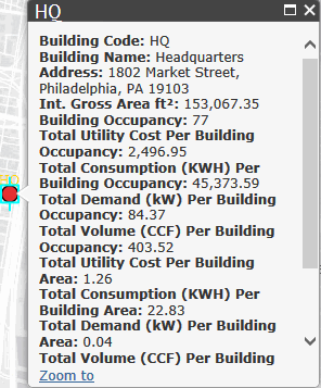
- Details. Click the marker and a pop-up window shows basic information about the building along with energy data. Click the Zoom to link to zoom the map to this location.
- Map Type: Use the Map Type list to select a map type, including World and USA maps.
- Highlight by. Once the buildings are visible on the map, you can click Highlight by..., and select one of several metrics to highlight the selected buildings by. A legend describes the numeric range for each highlight color.
- Total Utility Cost per Building Occupancy
- Total Volume (CCF)
- Total Demand (kW)
- Total Consumption (MMBTU)
- Total Utility Cost
- Total Volume (CCF) per Building Area
- Total Demand (kW) per Building Area
- Total Consumption (MMBTU) per Building Area
- Total Utility Cost per Building Area
- Total Volume (CCF) per Building Occupancy
- Total Demand (kW) per Building Occupancy
- Total Consumption (MMBTU) per Building Occupancy
- kWh or MMBTU: Select the units in which to display consumption values.
Note: The selection to display MMBTU or kWh applies only to energy consumption. The other measurements will still display using their standard setting. For example, power demand is always expressed as kW.