Real Property / Portfolio
Availability by Location Charts
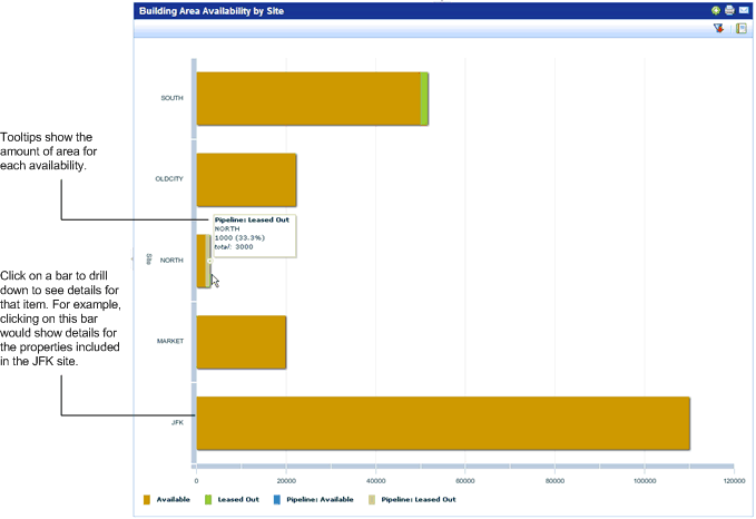
The Availability by Location Chart gives an estimate of the total area your organization currently has and its availability: whether it is:
- available to your organization
- leased or subleased to tenants
- in the pipeline for your use
- in the pipeline to be leased out to tenants.
For buildings, you can also generate the report grouped by facility type. You can generate this report for buildings (from the Building process) or for land (from the Land process).
You can filter the data shown in the Area Availability by Location chart by geographic location, or ownership. See Filtering KPI Charts.
If you group the chart by geographic location, you can click on a bar or line in the graph to drill down to see the details for the data for that item. For example, if you click on the line for a city in a chart showing buildings grouped by city, you see a chart with data for only that city. You can drill down to view a single property (for land) or site (for building). See Drilldown for KPI Charts Grouped by Geography.
Generating the Chart
You can generate the Area Availability by Location chart for buildings or for land by geographic location using the Portfolio / Buildings / Building Availability or Portfolio / Land / Land Availability.
Availability charts are also shown on the Portfolio / Buildings / Building Dashboard and Portfolio / Land / Land Dashboard.
You can generate the chart as a report. See Generating KPI Charts as Reports.
Business Result
The Area by Availability by Location chart:
- Helps you track the buildings or land that you lease or sublease to others.
- Provides you with data to answer the following questions:
- How much area do I have and where?
- How much of this area is available for our organization's use?
- How much of this area is leased out to others?
- How much of this area is in the pipeline?
Chart Example
The below image shows the Building Area Availability by Site chart. The bars for charts have tooltips that give the estimated area for each availability.