Leaflet Map Control
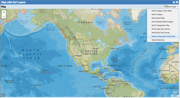
Map with Esri Layers
Technologies > User Interface Add-Ins > Geographic Information System (GIS) Views > Map with - Esri (Leaflet)
In this example the user is able switch Esri basemaps from a drop-down menu of available options. A series of basemap layers are made available through ArcGIS Online. Basemap options include imagery, streets, and topographic maps.
Add an action button for the basemap layers to the map panel:
<action id="basemapLayerMenu" type="menu"
imageName="/schema/ab-core/graphics/icons/view/ab-arcgis-basemap-16.png">
<title translatable="true">Basemaps</title>
</action>
To build the drop-down menu, first retrieve the list of available basemap layers using getBasemapLayerList():
var basemapLayers = this.mapControl.getBasemapLayerList();
Create a menu item, action, and event handler for each basemap layer :
var basemapLayerMenu = this.mapPanel.actions.get('basemapLayerMenu');
basemapLayerMenu.clear();
for (var i=0; i<basemapLayers.length; i++) {
basemapLayerMenu.addAction(i, basemapLayers[i], this.switchBasemapLayer);
}
When a menu item is selected, pass the selected item to the menu item's event handler and call switchBasemapLayer():
this.mapControl.switchBasemapLayer(item.text);
Esri Basemap Values
|
Basemap |
Description |
|
World Imagery |
Satellite imagery for the world and high-resolution imagery for the United States. |
|
World Imagery with Labels |
Satellite imagery for the world and high resolution imagery for the United States with world boundaries and place labels. |
|
World Light Gray Canvas |
A light neutral background to draw attention to your thematic content. |
|
World Dark Gray Canvas |
A dark neutral background to draw attention to your thematic content. |
|
World Topographic |
Administrative boundaries, cities, water features, landmarks, transportation, and buildings overlaid on land cover and shaded relief. |
|
World Shaded Relief Imagery |
Surface elevation presented as shaded relief. |
|
World Street Map |
Worldwide street map with highway-level data for the world and street-level data for the United States, Canada, and a number of European countries. |
|
National Geographic World Map |
A general reference map developed by National Geographic and Esri featuring the National Geographic cartographic style. |
|
Oceans Basemap |
A basemap focused on bathymetry, includes inland waters and roads overlaid on land cover and shaded relief imagery. |
View: http://localhost:8080/archibus/ab-leaflet-esri-switch-layers.axvw